


Explore ASEAN+6 pandemic responses with new interactive map

A new interactive map developed by Crawford researchers, together with ANU CartoGIS, provides researchers and policymakers with a one-stop platform to understand how countries in the ASEAN+6 are responding to the pandemic.
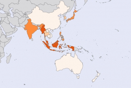
The global coronavirus pandemic has demanded responses across all areas of public policy. Every country has put its own complex set of policies in place to counter the health and economic costs of the coronavirus.
In response to this complexity, researchers from Crawford School developed an interactive map that highlights COVID-19 policies in the ASEAN+6 region and gives detailed information on legislative measures, case numbers, border controls, and more.
“The map will be useful to the wider public who are interested in understanding developments in the region. It also serves a one-stop platform that synthesises news and developments related to the pandemic across the region,” project lead Associate Professor Björn Dressel said.
“We wanted to look at why some countries in the ASEAN+6 appear to be doing a better job in managing the pandemic.
“There is a real need to understand variations in policy responses to the pandemic across countries in the ASEAN+6, and more specifically the ASEAN+6 group of countries (which includes New Zealand and Australia).”
The team at Crawford School includes Associate Professor Dressel, PhD candidate Fakhridho Susilo, Dr Yixiao Zhou, Dr Adam Henschke, and Dr Azad Singh Bali. To visualise the data the team worked closely with Sandy Potter from The Australian National University (ANU) CartoGIS team.
ANU Southeast Asia Institute provided financial support for the project and the New Mandala blog supplied content for the map.
The final product is set up to be a regional public good to track responses to the pandemic in a holistic manner and point towards shared challenges in the region.
“Ultimately we want to understand what some of the economic, social, political, and institutional changes are in response to the pandemic. Rather than focusing on one policy area, we hope to facilitate learning about how states have responded across various areas and how that has impacted the effectiveness of the response,” Dr Azad Singh Bali said.
“This project is a starting point to understand how different countries are responding to a series of common challenges that have been brought to the fore by the pandemic.”
The map relies on data from ANU and official sources and contains information on key variables of interest such cases, deaths, and vaccination rates and tracks state responses across constitutional, border, social, health, and economic policy.
“This data is depicted geographically and also provides readers with links to additional resources and references produced by experts within Crawford School and the College of Asia and the Pacific at ANU,” Associate Professor Dressel said.
“You can visit the page and click on the relevant tabs which provides users an overview of current or past trends. You can also zero in on specific country context information. External links for further information are also provided.”
Over time, the research team is hoping to produce quarterly reports for public discussion and to inform policy decision-making.
Take a look at the COVID-19 government policy response map.
Updated: 1 July 2024/Responsible Officer: Crawford Engagement/Page Contact: CAP Web Team


